

Marshfield Parish Council

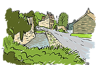
Marshfield rises 600 feet above sea level on the southern edge of the Cotswolds, nestled within a designated National Landscape. It appears in the Domesday Book of AD 1086 as ‘Meresfeld,’ meaning ‘Boundary’, a nod to its position between the Saxon kingdoms of Wessex and Mercia. Its layout, with long, narrow burgage plots and rear lanes, reflects its historical role as a market town dating back to 1234.
The town’s early prosperity was built on the wool trade, bolstered in the 18th century by the malting industry. Many of the houses lining the mile-long High Street originate from this era, lending the town its distinctive architectural character.

1. Toll House
Turnpiked in the 18th Century Marshfield was the first stage on the Bristol to London road. The building is a good example of Georgian Gothic architecture.

2. Alms Houses
In 1612, the affluent Crispe family constructed eight houses, a chapel, and a clock tower to provide shelter for elderly villagers.

3. Country Stores
Formerly Bodman’s Emporium, the shop was established in 1845 and still retains its original, now-listed fittings.

4. Tolzey Hall
Since 1690, the building has served many roles: a toll court, a boys’ school, the village fire engine house, and a lock-up. Today it is home to the parish council and also accommodates the public conveniences.

5. Catherine Wheel
Built in the late 17th century as a distinguished residence, it now stands as one of the few surviving pubs in a parish that once boasted thirteen. Its elegant façade includes a Queen Anne-era shell canopy above the entrance.

6. Old School House
The National School was built in 1861 and converted into private houses in the year 2000.
7. Weir Farm and pool
Once one of eighty 18th Century malting houses, it is now one of several working farms within the parish. The weir was a cart wash.

8. The Lord Nelson inn
Built in 1700 and is distinguished by a shell canopy entrance and a sundial.
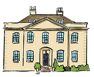
9. Old Vicarage
This handsome building served as the vicarage from 1720 - 1982.

10. St Mary The Virgin Church
A church has stood in the village since at least 1125. Rebuilt around 1470, It was damaged by Cromwellian troops in 1643 following the Battle of Lansdowne and has seen several restorations since.

11. Garston Farm Airstrip
Marshfield has its very own Airfield